Citizens of Connecticut’s 169 municipalities probably don’t spend a lot of time considering the zoning laws that determine what can be built and where. A statewide team including University of Connecticut researchers hopes to change that.
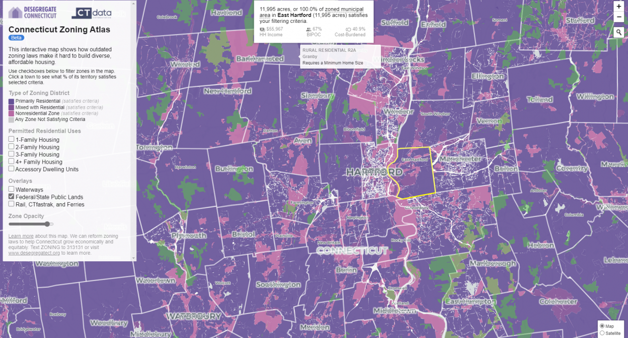
An interdisciplinary team of researchers developed the nation’s first interactive map that shows what kind of housing is allowed in each town to encourage equity, prosperity, and a cleaner environment.
The Connecticut Zoning Atlas project is led by Sara Bronin, Thomas F. Gallivan Chair of Real Property Law at UConn School of Law, through an advocacy group she leads called DesegregateCT. A first-in-the-nation tool, the Atlas allows users to visualize how each of the state’s 169 towns and 2,620 zoning districts regulate housing and shows the potential impacts. Bronin published a paper on the project in SSRN.
“We started DesegregateCT over the summer,” says Bronin. “With an initial group of architects, lawyers, and planners, we discussed the role of land use and zoning in segregation. People really wanted to do something to create positive change.”
Cary Chadwick from UConn’s College of Agriculture, Health and Natural Resources (CAHNR) and UConn Extension was one of those people.
Chadwick, an expert in geographic information systems (GIS) with the CAHNR Center for Land Use Education and Research (CLEAR), was excited about the opportunity to support a project that could directly impact the citizens of Connecticut at a time when the nation was having important conversations about social justice.
“Like so many individuals and organizations, we were talking about the murder of George Floyd and the increased focus on issues of race and inequity internally at CLEAR and in CAHNR,” Chadwick says. “It was about this time we became aware of DesegregateCT. We reached out to see how CLEAR might be able to help.”
Chadwick’s geographic information system skills were quickly put to use in the creation of the Connecticut Zoning Atlas. While the Zoning Atlas was a collaborative project, Bronin is quick to recognize Chadwick’s contributions.
“The Atlas was made possible by Cary’s incredible efforts, and it would have taken twice as long without her – if it could have been done at all.”
The first task for the Atlas team involved a research team painstakingly sorting through 32,276 total pages of zoning code text for all the state jurisdictions to identify specific zoning characteristics such as single versus multi-family zones, minimum lot size and floor area requirements, parking regulations, affordable housing provisions, and the availability and restrictions of accessory dwelling units (ADU’s).
Chadwick became the primary coordinator for the second part of the project, the map collection. Every zoning code has an associated map, though many of the towns had neither updated nor complete information. Chadwick worked with collaborators and volunteer GIS professionals, to collect and update the maps. In some cases, maps had to be created by digitizing hand-drawn illustrations.
With the code analysis and map assembly complete, CT Data Collaborative created the interactive map available to the public, which is the third and final part of the project. The interactive map allows users to filter the dataset to see zoning district type, if multi-family dwellings are permitted, and other pertinent data like median household income and the percentage of the population that identifies as Black, Indigenous, or person of color.
Some of the findings from the Atlas include that 90.6% of the state is zoned for single-family housing, while just 2.2% is zoned for housing for four units or more without a public hearing. There is a correlation between multifamily housing and the percent of non-white population. And ADUs are expressly allowed in 156 of Connecticut’s 169 towns, though some are subject to restrictive requirements.
DesegregateCT is using the findings to propose more areas where two-to-four-unit housing will be permitted without a public hearing and legalizing accessory dwelling units with fewer restrictions.
“The Connecticut Zoning Atlas is a gift to land use planners, and anyone invested in making our communities open to all people,” Chadwick explains. “It tells a story that cannot be seen by reading pages of complicated, written text. If we are really serious about addressing the structural and procedural practices that have contributed to economic and racial segregation across our state, then we need to prioritize zoning reform.”
Funding to support Data Collaborative’s work for this project was provided by the Community Foundation of Eastern Connecticut.