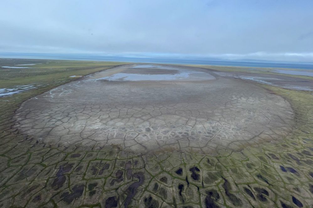
Scientists have long known that climate change is accelerating the melting of Arctic ice. But recently, a team of researchers including Chandi Witharana from UConn’s College of Agriculture, Health and Natural Resources, discovered that the warming planet is also causing Arctic lakes to dry up.
The team, led by University of Florida Department of Biology postdoctoral researcher Elizabeth Webb used maps Witharana helped create through a largescale effort to enable scientists to better understand what is happening in the Arctic. Witharana is an assistant professor in residence in the Department of Natural Resources and the Environment.
In 2019, Witharana joined a multi-institution NSF-funded project titled Permafrost Discovery Gateway: Navigating the new Arctic tundra through big data, artificial intelligence, and cyberinfrastructure The goal of the project is to create a “one-stop-shop” science gateway for scientists to access detailed satellite image information about the Arctic using big data and artificial intelligence.
“[This science gateway will help] researchers do better science and discover new knowledge,” Witharana says.
Using high spatial resolution satellite images from commercial satellites, this project is mapping the entire 5 million square kilometer Arctic permafrost tundra region using data from the past 20 years. This is no small task, especially considering the group is developing sub-meter resolution maps that will allow researchers to identify individual landforms – like lakes and ice-wedge polygons.
Webb used data from the NASA-operated MODIS satellite to construct her initial observations that lakes in the pan-Arctic region, spanning parts of northern Canada, Russia, Greenland, Scandinavia, and Alaska, are drying up as the permafrost under them thaws. She then used Witharana’s pan-Arctic surface water map, which provides much higher resolution, to confirm her findings. Webb published these findings in Nature Climate Change.
MODIS has a resolution of about 500 meters. The commercial satellites the gateway uses have a 0.5m resolution.
“It’s a whole new holy grail of satellite data,” Witharana says.
Permafrost is deeply frozen soil. When it thaws, water can drain out of the lakes. This process also increases soil erosion into the lakes. These lakes are a critical fresh water source for Indigenous communities in this region as well as threatened and endangered species.
The Permafrost Discovery Gateway will help scientists visualize and understand how the permafrost is changing, an important consideration since artic permafrost stores approximately 1,460 to 1,600 billion metric tons of carbon, about twice as much as currently contained in the atmosphere, according to the National Oceanic and Atmospheric Association.
Witharana is also imaging other land features, like ice wedge polygons. Normally, ice wedge polygons look like U-shaped depressions in the surrounding landscape. But when they thaw, they become convex structures. These changes can alter water flows, Arctic topography, and carbon storage.
“It has a big impact on hydrological processes,” Witharana says.
The project is also identifying where human-built infrastructure like buildings and roads are located, so researchers can understand how the areas where people live and work may be impacted by these changes.
The project is funded for the next two years and is expected to have wide-reaching impacts as scientists continue to make use of the gateway.
“This work [provides] fundamental understanding of how the Arctic is responding to climate change,” Witharana says.
Follow UConn CAHNR on social media