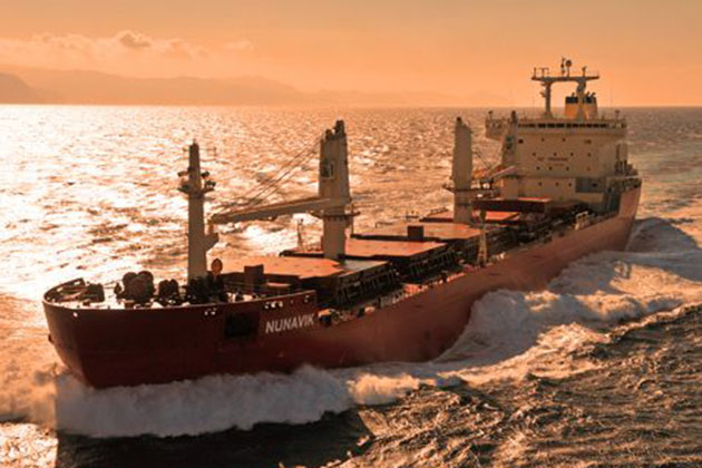

The MV Nunavik made history last September when it traversed the fabled Northwest Passage without the help of an icebreaker. It was the first cargo ship ever to do so, but it likely won’t be the last.
As the climate warms over the next few decades, Arctic shipping routes will open more often, which could save significant amounts of time and money for both companies and countries.
UConn’s Scott Stephenson, assistant professor of geography, is charting the possibilities for the future of Arctic shipping lanes.
At this year’s meeting of the American Geophysical Union, Stephenson and Laurence Smith of the University of California Los Angeles, presented the scenarios for three potential routes through the Arctic: the Northern Sea route along the northern coast of Russia, the Northwest Passage through the Canadian Arctic, and the Trans-Polar Route over the North Pole.

The Northern Sea Route would cut travel time between Rotterdam and Yokohama by as much as 40 percent. The Northwest Passage and the Trans-Polar Route are attractive for similar reasons – if they are navigable.
To get an idea of which routes could be navigable by mid-century, the researchers ran shipping simulations for 10 well known climate models through the year 2060. They were surprised at how dramatically the models differed from each other – particularly because the models had agreed when they (accurately) predicted sea ice in the past.
The biggest surprise centered on the Northwest Passage. Two of the models showed it thawing earlier and more reliably than the Northern Sea route. Yet, currently the Northern Sea route opens earliest and most reliably. The Northwest Passage might be usable occasionally, but has a tendency to collect ice from other parts of the Arctic, clogging the narrow straits between the islands.
“Those models project more and thicker ice along the Eastern Arctic, which is not what we expected,” Stephenson says.
Eight of the models show the Northern Sea Route as the least costly route overall, favored by cargo ships from Rotterdam and Halifax to Asia sometime between 2011 and 2035, while two of the models show the Northwest Passage as the least costly. By 2060, a few of the models even show the great circle route over the North Pole becoming accessible for part of the year.


Maps showing potential shipping routes in 2011-2035 (left) and 2036-2060. Each line shows a potential route for a ship; the numbers associated with the color of each line are the average density of possible transits along that line over the 10 models. (Images courtesy of Scott Stephenson)
The Northwest Passage has captivated navigators since Europeans first encountered the New World, but sea ice and the complex geography of what is now the Canadian Arctic foiled them until recently.
The Norse, who explored Greenland and North America during a particularly warm period during the 11th century, got as far as Ellesmere Island. It took until 1903-1906 for Norwegian Roald Amundsen and his crew to be the first Europeans to make the passage. They traveled in a sloop that could handle shallow water.

Modern cargo ships need deep water, which limits their potential routes through the passage. The Nunavik draws 10.2 m (33 feet) of water, and is at the smaller end of the size range for cargo ships. As a polar class vessel, the Nunavik also has a fortified hull that can withstand up to 1.5 meters (5 feet) of ice traveling at 3 knots. In September 2014, she carried 23,000 tons of nickel ore from Deception Bay in northern Quebec to Bayuquan in China, completing the Northwest Passage from Port Deception to Alaska’s Point Barrow in just 11 days.
Currently most ships that enter the Arctic move similar cargo, ore, or oil that originates in the Arctic. That could change by mid-century, if the models run by the researchers prove accurate.
However, the costs of a route change depend on how many ports-of-call it contains. Cargo ships generally stop at several ports during a single run; the Arctic routes have fewer potential ports-of-call than the longer routes through either the Panama or Suez Canal.
One thing the models generally agreed on was the seasonality of Arctic shipping. In the early years, they showed that any navigation through the Arctic would need to take place between the months of July and October. But by 2060, ships with reinforced hulls like the Nunavik could have a season as long as nine months.
The researchers’ findings are also relevant to various governments that are keenly interested in Arctic navigation. Russia, Canada, Norway, the U.S., and Denmark all have territorial claims to land or waters in the Arctic. Canada, for example, claims the Northwest Passage as a Canadian waterway, while the U.S. and Russia insist it’s international. As access to the Arctic Ocean increases, additional claims over the Arctic seabed may arise.