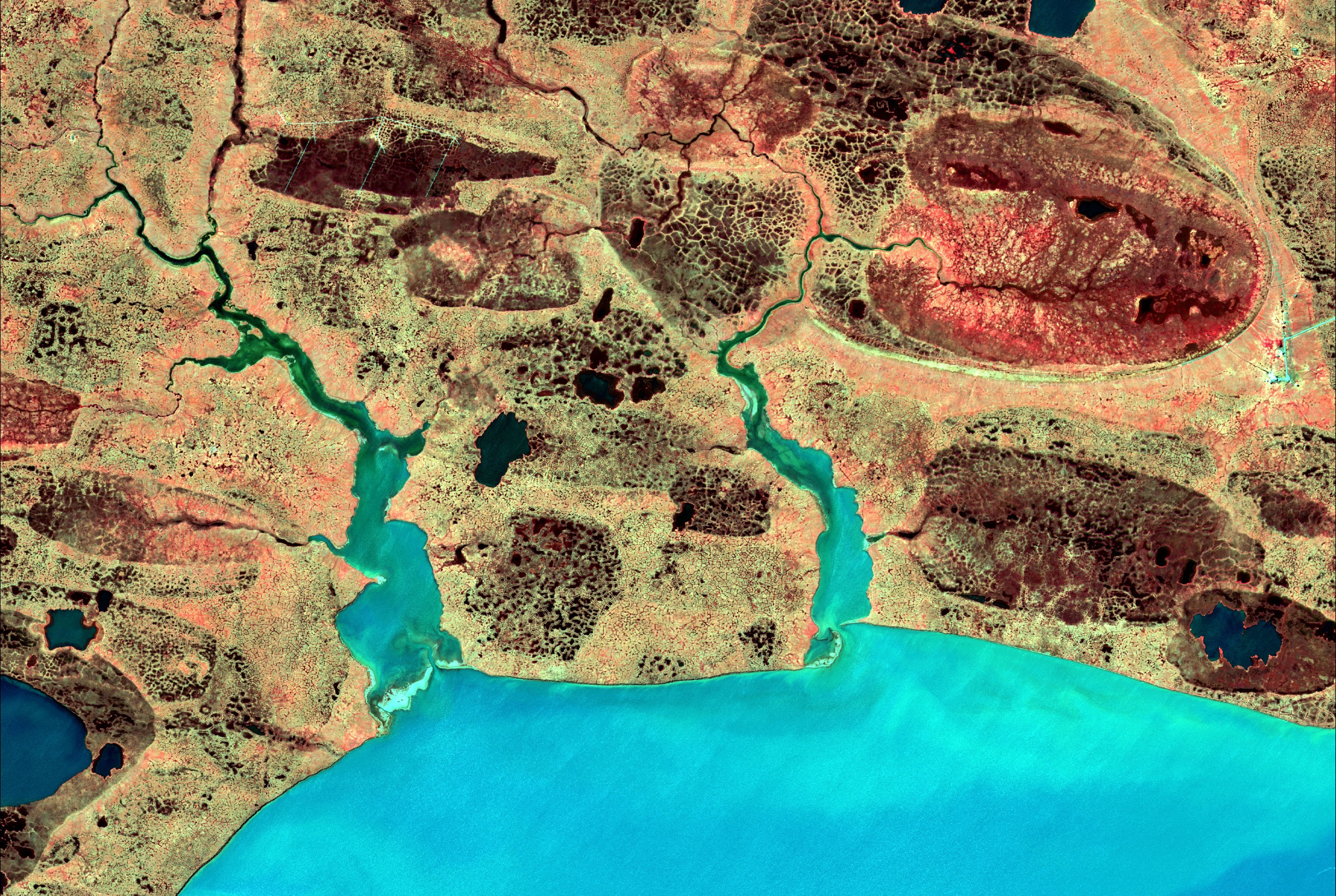

At first glance, the high-resolution images of the polygons look like the lacy skin of a cantaloupe melon – perhaps not what would be expected of images of the Arctic tundra. But this characteristic feature of the tundra is a perfect focus for remote sensing technologies and for studying the rapidly changing landscape of the region.
From the Antarctic to the Arctic and areas in between, Chandi Witharana is applying powerful remote sensing technology to study global problems.
Witharana, a visiting assistant professor in UConn’s Department of Natural Resources and the Environment, says remote sensing is “a virtual passport” to these remote areas, allowing him to carefully monitor the harsh landscape from his grizzly bear-free computer laboratory on campus.
He and his collaborators are currently mapping thousands of square meters of the Pan-Arctic, using satellite images to collect data. The images offer a resolution so powerful that anything larger than 30 centimeters can be imaged from space, enabling the researchers to study areas across the globe that would be difficult or impossible to survey otherwise.
For the Pan-Arctic project, satellite images are taken roughly every two days, over a massive stretch of land encompassing parts of Alaska, Canada, and Siberia.
Each point or pixel within each image is identified by its geographical location, using latitude and longitude, and this geo-referencing is used to mesh the data together using super computers. The researchers then compare various features between images taken over time, noting changes or trends.
In the Arctic tundra, the researchers are seeing degradation proceeding at an alarming rate.
“Previously it was thought that topography was fixed, needing millions of years to change,” says Witharana. “But this degradation is happening within the span of a decade.”
Without remote sensing technologies, collection of this type of data over such vast expanses of land would be cost-prohibitive, dangerous, and potentially impossible for humans to accomplish, since many areas are remote and cannot be reached even by helicopter.

Remote sensing is also a vital tool for an entirely different kind of extreme – wars and their effects on civilian populations. Working with the United Nations, Witharana studied how people migrate under forced conditions, where refugee settlements are established, and the number of those affected.
Due to the chaos inherent in war, the only unbiased and accurate measures of refugee populations are those gathered using remote sensing, says Witharana. “You cannot trust any other source in conflict situations. It is not possible to report exact numbers from the ground.”
Witharana has not only used the technology for his own research, he has introduced it to K-12 STEM classrooms as part of the Next Generation Science Standards. Using their own virtual passports, students can apply tools like Google Earth and StreetView to go on virtual hikes, exploring the Antarctic landscape and areas such as Deception Island and Bailey Head, and study the penguin population.
After a little tweaking, Witharana says, the technology can become a valuable tool in gathering information about almost anything you are interested in. The possibilities are as vast as the landscapes surveyed.
“This is everyday science, it is artwork, and it is a rich educational tool.”
Witharana is also participating in UConn’s Metanoia on the Environment, and will be holding a satellite image gallery during the week of Earth Day. The gallery will present appealing patterns, shapes, colors, and textures of the natural and human-made landscape, as well as sentient views of forced migration, violence, and destruction triggered by autocracy, racial aggression, and ethnic tension. The intent is to prompt viewers to observe and recognize the beauty in the world, and to contemplate the role humans play in its shaping.
This project is funded by the National Science Foundation Arctic System Science Program Award # 1720875.