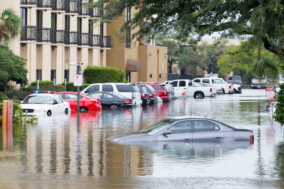
If you live in a flood prone area, would you — or could you — take measures to mitigate flood risks? What about others in your community? These questions are becoming more urgent, according to The World Resources Institute, because global flood risk is increasing, and loss projections for rivers alone put the cost over 500 billion dollars by midcentury.
Research published this week in Proceedings of the National Academy of Sciences from scientists from the University of Connecticut, the University of Maryland’s National Socio-Environmental Synthesis Center (SESYNC), the University of Massachusetts Amherst, and the London School of Economics, suggests that in the United States, the social reality of race inequity is an important factor influencing flood risk behavior, along with hydrological factors like stream flow.
This research started with the complexities of studying human behavior in mind, says UConn Assistant Professor of Natural Resources and the Environment James Knighton, when the researchers decided to look at a model designed to approximate how populations respond to flooding events.
“I was talking with one of my colleagues, Kelly Hondula, and we were looking critically at these models of human behavior and thinking they’re too simple and there is no way they could apply to US cities,” he says. “How could they be useful? Originally we were writing this paper to show that these models may only apply to community flooding dynamics in very carefully controlled case studies.”
“We started with data from over 200 cities that had long records of streamflow from USGS,” explains Kelly Hondula, formerly of SESYNC and currently a postdoctoral fellow at Battelle’s National Ecological Observatory Network. “Although the model only worked for a subset of those, we were surprised that there were so many cities where the model could explain patterns in the data quite well given how complex the interactions are between flooding, risk mitigation, and structural inequalities.”
The researchers tailored the models to 50 metropolitan areas across the US at risk for river flooding events, says Knighton. “These are models where you feed in a time series of flooding hazards that happen every year. The model uses streamflow information to predict how much damage occurs in a flood, how much a given flood changes a community’s behavior, and how lasting are these changes.”
They further calibrated the models to include trends in behaviors related to flood insurance policies and claims.
Knighton says, “After running the model, we were totally shocked because it worked fairly well. We shifted our focus to see what this model is saying about these communities.”
The models show two diverging patterns among US metro areas: one the researchers deemed “risk enduring,” with lower flood defenses and a longer local memory of past flood events; and “risk averse,” with higher flood defenses and a shorter memory regarding previous floods. Risk averse patterns tend to be found in areas with larger dams and a higher proportion of white residents, while the reverse is true in risk-enduring metropolitan areas.
In risk-enduring cities, the aftermath of flooding brings a sharp rise in the purchase of flood insurance policies, which then declines quickly. In risk-averse cities, the number of flood insurance policies tends to be more stable; major floods bring a slight increase in insurance policies, which also don’t drop off as sharply as in the first pattern group.
Professor Christian Guzman of the University of Massachusetts Amherst says the researchers were mindful of how they described the diverging patterns: “Some models have termed a certain group as ‘risk-taking’ (versus risk-averse), but we decided to reorient this to indicate risk-enduring populations, meaning these groups are probably enduring the risk of flooding despite risk-preference or any agency associated with these preferences. This was something we found to be important when discussing flood risks and history in the U.S.”
To learn more about these communities, the researchers, including Rebecca Elliot at the London School of Economics, analyzed census data for the cities to see if measurements of social vulnerability could describe the divergent patterns, which Knighton says was immediately apparent. Socioeconomic demographics were the main split between the patterns, with the proportion of white residents higher in risk averse communities, where there are fewer fluctuations in flood insurance policy numbers.
“Our thinking was that poverty and race may indicate socioeconomic barriers to participate in existing federal programs such as the National Flood Insurance Program (NFIP),” Knighton says, referring to the federal initiative that provides flood insurance policies to homeowners, businesses, and renters in roughly 23,000 communities at high risk of flooding. “There is probably also some aspect of this where people are rational actors in the economic systems where, if they perceive a big risk, they will take some sort of action to mitigate the risk, and if they don’t perceive a risk, they won’t. The National Flood Insurance Program is built around this belief.”
The researchers started from the opposite end of the spectrum, assuming there are no social barriers to people acting as rational actors, says Knighton. “We asked, Is there some component of this that is actually tied to the risks people are facing? That is why we looked at stream flow and how predictable it is for people who live near it.”
This predictability can be measured with a variable called “flashiness.” A stream that is likely to stay at roughly the same level day-to-day is less flashy, whereas flashy streams have drastic and less predictable level fluctuations.
“Overall, we saw two things,” says Knighton. “Race and flashiness together were very strong predictors of insurance dynamics,” with flashier streams corresponding to risk-averse metropolitan areas with higher proportions of white residents.
Risk averse communities also tend to have more local investment in their flood control infrastructure, such as more and bigger dams says Knighton, with more federal attention directed at larger, richer, and whiter cities.
Knighton explains that barriers such as affordability and bureaucratic red tape may make access to insurance difficult and inequitable. Accounting for all these factors led to this research being the most comprehensive model-based investigation of flood risk behaviors in the US to date. There are programs in place designed to make federal flood programs more accessible; however, inequities remain, and the researchers hope this research will raise awareness.
“It seems like there is a very rational component to the insurance market where people have some basic understanding of hydrology and can assess their local risks and they’re taking action, but there are also barriers,” says Knighton. “The barriers of race, and likely poverty, are limiting certain communities or individuals from participating.”
The Federal Emergency Management Agency (FEMA) has been committed by Congress to investigate an affordability framework which would be a way for the National Flood Insurance Program to apportion flood insurance more equitably. However, action needs to be taken quickly.
“Part of our hope is that there is strong support for a comprehensive affordability framework,” says Knighton. “Some cities just live with risk. Flooding will likely get worse in the near future. Maybe people are able to live with the flooding we have now, but we can’t know for certain if everyone can live with the flooding that is coming.”
This work was supported by the National Socio-Environmental Synthesis Center (SESYNC) under funding received from the National Science Foundation DBI-1639145.