In a new paper published in Remote Sensing of Environment, a team of UConn researchers from the Department of Natural Resources and the Environment (College of Agriculture, Health and Natural Resources) proposes a new framework that emphasizes the multifaceted nature of land change through the lens of remote sensing.
Many scientists are studying land change using remote sensing satellite data. But, given that land change science is still relatively new, there is often confusion about what language to use to describe what, exactly, people are observing.
Zhe Zhu, assistant professor and director of the Global Environmental Remote Sensing Laboratory (GERS), is also editor for multiple remote sensing journals. In this capacity, he noticed many authors using terms that have different meanings interchangeably, something he noticed this among his own lab members as well.
“I think the most important problem is that land change is an extremely complicated term,” Zhu says.
Land change is not a binary process in which land either changes or does not. It is a multifaceted and dynamic process, meaning scientists need a consistent and systematic framework to accurately describe their observations.
In their recent publication Zhu, Research Assistant Professor Shi Qiu, and postdoctoral researcher Su Ye define the need for a multifaceted perspective in remote sensing of land change.
“If you look at different facets of land change, you see different aspects of change,” Zhu says.
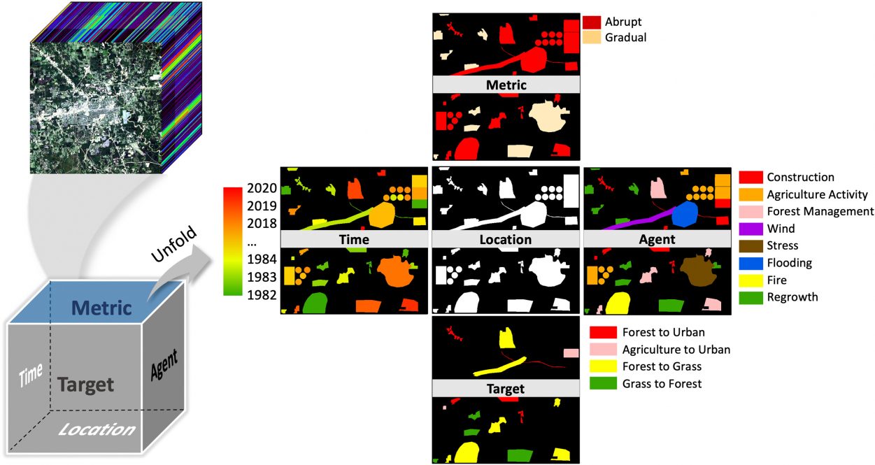
There are five major aspects of land change the authors define: location, time, target, metric, and agent. The location is where the change happens. The time is when the change happens. The target is what is changing; this can be factors like how the land is being used and what the land cover looks like. The metric describes how the land is changing; this aspect considers factors like if the change is abrupt or gradual, subtle or dramatic, and the duration of the change. The agent, or driver, explains why the land is changing; this can be something direct like a natural disaster, human construction, or an insect infestation. There may also be distal drivers, which are less direct forces like changes in human population or land management policies.
If you look at different facets of land change, you see different aspects of change. — Zhe Zhu
Qiu’s work is addressing this final aspect with a project that uses the group’s previously developed algorithm to map land change location and time, and combines it with machine learning algorithms that can define the drivers of land change in the conterminous U.S.
The paper emphasizes scientists publishing in this field should first clearly identify which change aspect they are talking about, then consider the multifaceted nature of land changes, and third, engage in multi-source data fusion.
Incorporating data from multiple sources and even other fields is critical to creating an accurate picture of land change.
As part of this paper, the researchers reviewed the current available global and North American remote sensing land change datasets. They found these datasets only capture one or two aspects of land change.
Data from the social and environmental sciences can contribute important ancillary data. For example, data on human population density and poverty levels can provide insight into the drivers of land change not captured in satellite data.
Scientists can even use social media to capture near-real-time images of land conditions. For example, during a natural disaster, data from social media can be combined with satellite data to determine where an image was taken and gather important information about the conditions on the ground.
“This is a direction we think will be very important in the future,” Zhu says.
Another problem the paper addresses is that when using satellite data, scientists have access to a tremendous wealth of information about where and how the land is changing. But this data also includes noise that scientists need to untangle.
Ye is developing a model that can isolate subtle land changes, which are often confused with noise.
“Usually, subtle change and data noise would be very easy to mix up, so we need some sample data to direct our models,” Ye says.
Zhu says his research group plans to implement this framework moving forward to investigate all aspects of land change from this multifaceted perspective, a framework he says will be useful for others in the field as well.