Waves play an important role in the global carbon cycle, mixing and churning in oceans to capture and store atmospheric carbon in the seawater. But getting a full picture of wave activity is challenging, because it’s not easy to measure something that, by definition, is always moving, changing, breaking, and dissipating. Satellites and even wave measurements taken on buoys are not enough to capture the full picture, leaving researchers to make assumptions.
One UConn Ph.D. student is working to change that.
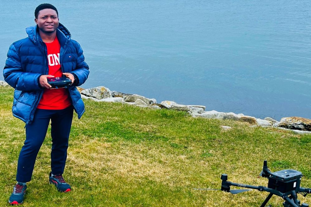
Bernard Akaawase, a doctoral researcher in Assistant Professor Leonel Romero’s lab who focuses on physical oceanography, is developing a wave measurement system that uses a drone and existing measuring techniques to reconstruct detailed three-dimensional ocean waves to analyze breaking waves. Romero and his research group study the processes that control the exchange of gases across the air-sea interface.
“Our work focuses on developing highly sophisticated models so we can better predict these processes. Specifically, we focus on ocean waves, and waves breaking is one of the key aspects that we’re trying to better understand,” says Romero.
Wave-breaking in the open ocean is one mechanism that can draw excess atmospheric CO2 into the water column, and without those breaking waves, Romero says the carbon capture would happen at a much slower rate. His lab performs detailed measurements of the ocean surface to develop highly sophisticated models to better understand and predict these important processes.
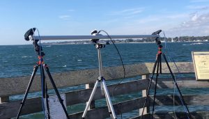
“Currently, we can study several of the processes on the ocean surface using a stereo system, which is comprised of two cameras that are synchronized to get images of the sea surface at a very high rate up to 12 frames per second. We use those images to reconstruct the ocean surface elevation,” explains Akaawase. “We also have LiDAR (Light Detection and Ranging device) that measures the distance of objects, that way, we’re able to get several measurements.”
Akaawase explains that they need to know the height, crest length, speed, and direction of the waves in space and time to be able to describe wave-breaking, which is where the drone comes in.
The researchers are interested in the crest of the breaking waves, for instance in measuring the velocity and how long the breaking crests are, and after analyzing over 21,000 images collected from an offshore platform, they have been able to calculate a distribution that describes the speed, length, and direction of breaking wave, says Akaawase.
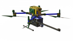
Akaawase designed a drone sensor carrier to include an onboard LiDAR, camera, computer, and GPS-aided inertial measurement unit (IMU), in addition to other devices to assist in gathering the data needed to reconstruct the wave images.
They have started printing some of the components for the prototype they plan to build this summer to taking measurements for their studies, and Akaawase is excited to get started.
“We will start gathering detailed measurements of the ocean waves. With that information, we could detect and measure breaking waves and be able to describe several physical processes, such as the amount of gas being collected by waves in the open ocean,” he says. “We could also look at the whitecap coverage, which is important for interpreting the data collected by satellites. We could even quantify the amount of energy that is dissipated as the waves are breaking and several other quantities like momentum flux, which directly forces the ocean currents, so we could do a lot of analyses with those measurements.”
Drone piloting is something Akaawase has long been interested in. He began his studies as an undergraduate in the marine engineering department at the Federal University of Petroleum Resources in Nigeria, where he graduated at the top of his class. Akaawase learned about Romero’s publications and connected via email, which set him on the path to UConn.
“I reached out to Leonel to say that I want to work with him,” Akaawase says. “I always wanted to do science from an aerial view, like flying drones, and when I finally got to fly, I fell in love. When the research topic was introduced to me, it was exactly what I wanted to do, which I never before had the opportunity to start. It was very, very exciting.”
After his studies at UConn, Akaawase hopes to return to Nigeria and make waves by becoming a university professor, and eventually get involved in politics.
“I hope to leverage the acquired knowledge and privileges of being a professor to become the governor of my state, and perhaps the president of Nigeria at some point.”