Cassie Aimetti ’25 (CLAS) carried two rectangles of plywood, one under each arm, as she walked down the wooded trail leading toward the Quinnipiac River, the dense branches that arched overhead forming a shaded tunnel under the morning sunshine.
She’d only walked this trail once before, when a guide had led her through the network of well-worn pathways that wound past active osprey nests, through stands of wildflowers and invasive knotweed, and out toward her ultimate destination – the salt marsh.
This second time on the trail was different, though. Because this time, Aimetti was one of the leaders. This was her project.
Wearing a brand-new pair of white overalls that wouldn’t stay white for much longer, Aimetti led a group of more than 20 people down the trail, all joining on the day’s adventure out to the salt marsh and to the tiny island nestled within it.
Each person carried the equipment needed to accomplish the day’s tasks, because, as they were briefed at the outset of the hike, it doesn’t matter if you’re the intern or the tenured professor – when you’re out in the field, everyone pitches in.
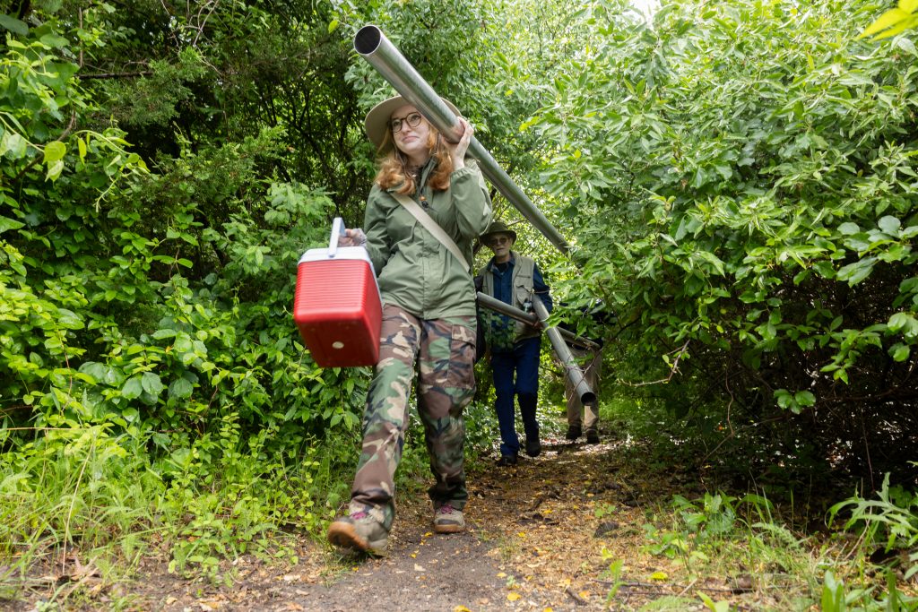
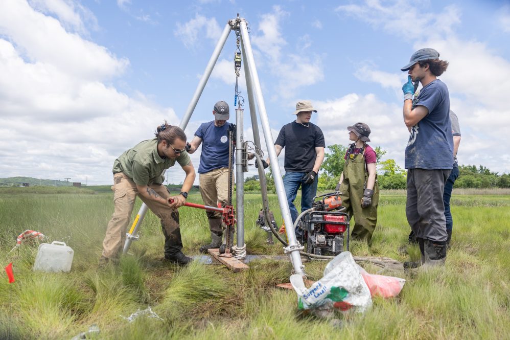
Their cargo included bags containing the myriad tools of the trade. Electric metal shears, paint scrapers, pipe cutters, and red plastic caps. Rolls of duct tape and kitchen cling wrap. A green rubber garden hose and a length of nylon rope. Those pieces of plywood. A wheeled cart carrying a well-used Honda generator, a tall aluminum tripod, and a red steel hand jack.
And the long, hollow aluminum tubes – those were to be the star of the day’s show.
The early-morning downpours at the New Haven shoreline had given way to winds that whipped up the river from the nearby Long Island Sound. Low tide would hit at 11:30 that morning, after which the water levels on the marsh would slowly start to rise. Time was limited, and there was a lot to get done.
After brief introductions at the edge of the marsh, the precarious part of the hike really began.
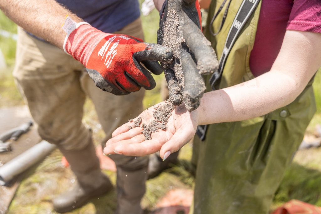
Swaths of marsh grass were intermingled with deep trenches of rich, black mud, the banks lined with colonies of fiddler crabs – thousands of them scurrying into their burrows as every footstep’s vibration traveled through the thick peat surface of the marsh, making the ground itself feel wobbly underfoot.
Impossible to tell from the surface just how deep those trenches went, the field team carefully picked its way across the wide swath of marsh between the trail and the island itself, to little avail. Progress was slow, as person after person found themselves half swallowed in the thick mud.
Hand-to-hand, they passed the equipment along, helping to wrench each other’s waterproof boots out of the mire.
Even Aimetti herself wasn’t immune, her new overalls now stained to the hip. It didn’t matter, though – the team hadn’t trekked out into a salt marsh on a Thursday morning for a fashion show.
What they were there to do was to begin a process of reconstructing the past environment of Grannis Island, the small and currently uninhabited landform on the edge of the river that was once actively used by Indigenous communities for thousands of years.
And that process would start with sediment coring.
Deep Into It
Aimetti, who grew up in Plainfield and always knew she wanted to one day attend UConn, didn’t start her college career planning to wade through salt marshes.
The rising senior initially came to UConn as a fine arts major.
“I still have a studio art minor,” she said. “But what happened is that I took an intro geology course for a lab gen-ed, and I just fell in love with it.”
She’s always loved the outdoors – hiking and camping – and, as a child, used to say that she wanted to be an archaeologist in the same way that other kids wanted to be an astronaut or a firefighter or a veterinarian.
“It’s like the most random thing that a fifth grader would say, ‘Oh, I want to be an archaeologist,’” she said. “But I always liked that stuff, the idea of the past. I love old documentaries. My dad and I had a metal detector, and we would go to beaches. Recovering lost past – that has always been interesting.”
After that geology course, she changed to a dual major – geology and art – before taking another gen-ed in anthropology and finding herself pulled in even deeper.
She’s now a double major in geology and anthropology, with a strong interest in the subfield of geoarchaeology, a multidisciplinary approach that uses methods and theories developed through earth sciences to examine questions related to human settlement, history, and artifacts.
She describes herself as a “hands-on type of person,” and right away, she started looking for opportunities to work in a geosciences lab at UConn, which is how she met associate professor Will Ouimet, one of her mentors and advisors and a geologist and geomorphologist at UConn.
Aimetti joined Ouimet’s lab, initially working on Ouimet’s ongoing, large-scale coastal sediment coring project in collaboration with the USDA’s Natural Resources Conservation Service, or NRCS. She spent time working at the NRCS offices last summer, and she’s also interning with Heritage Consultants – a cultural resource management firm based in Connecticut led by a trio of UConn alumni – where she’s been processing sediment cores taken at the historic settlement in Jamestown, Virginia.
“Once I had all that experience, where I had a little bit of field work, where I was opening the cores with NRCS, and then I was doing some lab work where I was analyzing the cores from Jamestown, I was able to learn enough be able to think of a way to apply this to something else,” she said.
“So, it was kind of just one thing leading to another, and I was like – I don’t even know. That’s the crazy part, really. I’m so deep into it,” she added.
It sort of explains how she ended up in mud-covered overalls, preparing to drive 10- and 24-foot-long aluminum tubes straight down into the depths of a New Haven salt marsh.
“I feel honored to choose this site as the location for my undergraduate research thesis,” Aimetti explained, gesturing toward the small island amidst the marsh. “Grannis Island has been a known Indigenous site that has undergone unpublished excavations for decades, but no geological work has been done. And I believe that the work here deserves to be continued and brought to light.”
To the Core
Located in what’s now the Quinnipiac Meadows Eugene B. Fargeorge Nature Preserve – a 35-acre preserve, one of six maintained by the nonprofit Gather New Haven – the 9-acre Grannis Island wasn’t always uninhabited.
Archaeological work done at the site has uncovered evidence of heavy human occupation, particularly by the Indigenous Quinnipiac tribe, at least since 7,000 or 8,000 years ago. Excavations began at the site in the 1940s and uncovered evidence of fire pits, shell middens, and even dog burials on the site.
Materials related to the earlier excavations on Grannis Island are today held in the state’s archaeological collections at UConn, according to Connecticut’s state archaeologist, Sarah Sportman ’11 Ph.D., who brought students from her summer field school out to the site that late May morning to see Aimetti and Ouimet’s sediment coring team in action. Sportman’s office has been actively re-cataloguing and reanalyzing the archaeological site since 2021.
“This is a great site for us, because it gives us the opportunity to use one of the collections that we have at UConn and to pair it with modern methods, modern perspectives, to learn more than we knew about it in the past,” Sportman said. “It showcases the value of our legacy collections, and the potential of them, and also provides a way for us to learn something new, for Cassie to learn about coring and geomorphology, and for us all to come up with new information about this site.”
Scientists, geologists, and geomorphologists collect sediment cores as a way to look into a landscape’s past. At the most basic level, a sediment core is a type of soil sample that captures the earth’s stratigraphic layers while preserving the sequence of deposits – younger sediments are at the top of the core while older sediments are at the bottom.
Analyzing the composition of the layers in a core can offer clues about how the landscape developed, how it changed over time, and how factors like climate change or sea level rise might have impacted the environment.
“We are here to study the landform history of Grannis Island,” Ouimet said. “Today, it’s elevated only a couple meters above sea level, with the Quinnipiac River to the west and a beautiful example of a Connecticut salt marsh to the east. But how did we get to today? Sea level has been rising slowly for thousands of years, and the river has likely been eroding away its shores. How can we better understand these changes? And how does this landform history interact with the history of human occupation at the site? Given that sea level has been rising, the landform was likely bigger in the past and is now submerged. How can we reconstruct its previous extent?”
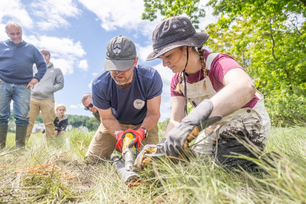
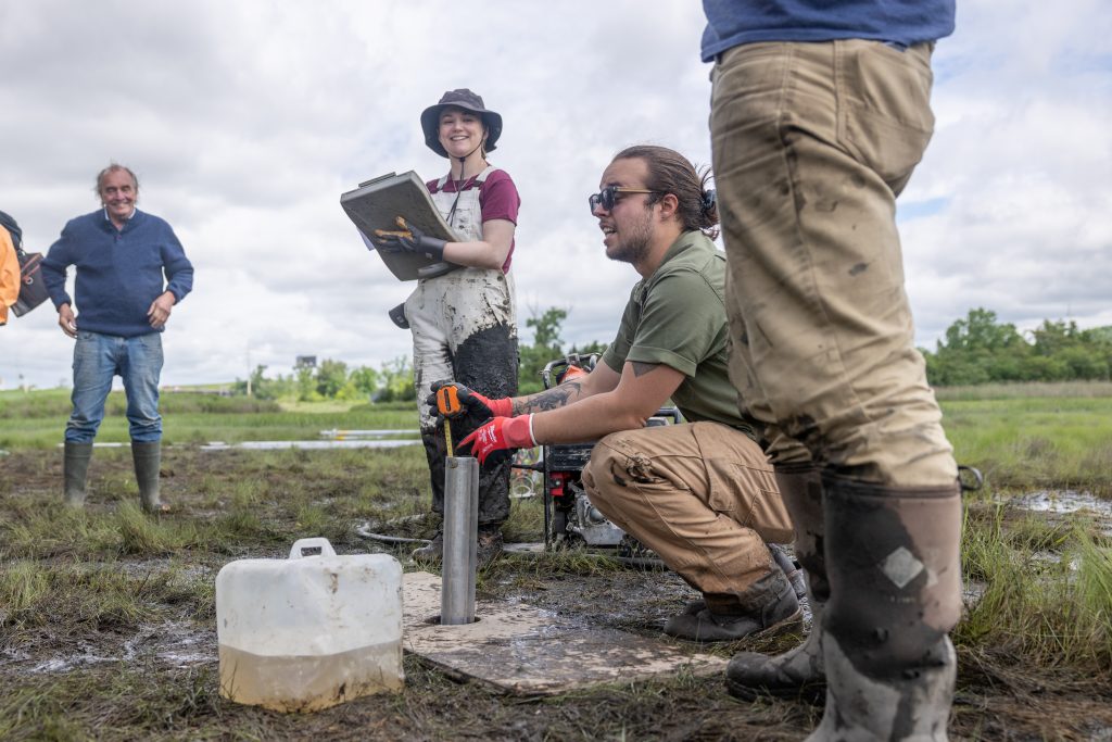
In principle, the process the team planned to use at Grannis Island – called vibracoring – is pretty straightforward. The long aluminum core tubes are attached to a concrete vibration device, powered by a gas generator, which helps push the tube deep into the ground.
The reality, though, is a combination of skill, finesse, and a whole lot of muscle. The vibration helps the metal tube slide through sand, silt, stone, and gravel, and to cut through organic materials that seek to slow it down.
It slides down easily at first, but as it gets deeper, it’s pretty typical to see Ouimet or another team member precariously balanced, jumping on top of the tube itself, trying with all their weight and might to force it as far into the ground as possible.
Once it can sink no further, the tube is capped before it’s slowly pulled out, creating a vacuum within it as it’s slowly lifted from the ground with a winch or a jack – like putting your finger on the top of a liquid-filled drinking straw before pulling it out of a cup, trying to hold the contents inside.
It’s not a quick process.
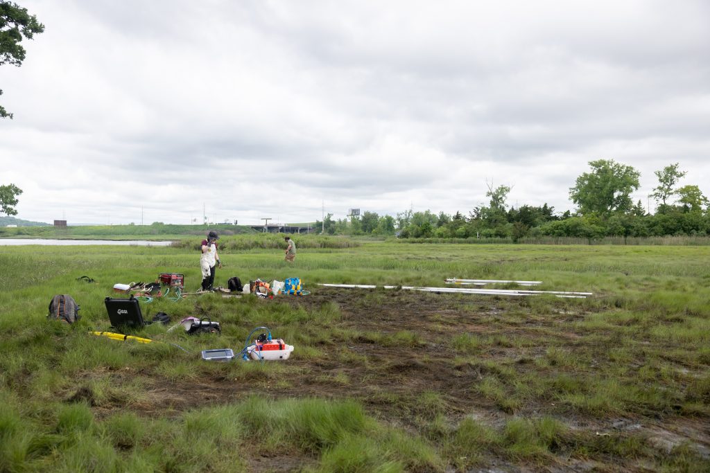
On this first outing to take cores from Grannis Island, they planned to sample the salt marsh, the river, and the island itself to try to learn about the three main aspects of earth surface processes occurring at the site.
Aimetti not-so-secretly hoped to also break Ouimet’s depth record – the longest core he’s pulled got to about 21 feet deep – but it wasn’t in the cards for the day. Their efforts got them to a respectable 15 feet on their deepest attempt.
They ultimately pulled four long cores that day – and a fifth smaller core from the island, where they quickly hit dense rock and shell – each core with its own story to tell about the history of this place.
How and Why
Exactly one week later, in the sediment coring lab in Storrs, Aimetti – alongside graduate student Preston Senderoff ’22 (CLAS) and fellow undergraduate Zak Knowlton ’25 (CLAS) – prepared to open the cores taken at Grannis Island.
They clamped sections of the cores, which were broken down into smaller pieces for easier transport and handling, onto a table and marked them, then sliced them open on each side with an electric shear – splitting each carefully in half, like opening a book, to keep as much of the material intact as possible.
The first long core showed layers of red sand and gravel, topped by a thick layer of marsh grass.
The next – taken just feet away from the first – could not have been more different. Dense and dark and wet and pungent – dotted at the bottom by whole pieces of preserved white oyster shell and gray sand full of tiny bits of red garnet – the smell of decaying organic matter, likely eel or sea grass Senderoff noted, started to fill the lab and travel down the first-floor hallway of Beach Hall as soon as the tube was sliced open.
“The sea grass doesn’t smell like salt marsh,” Senderoff said. “That smells like rot.”
“You get used to it,” said Aimetti.
Opening the cores is just the first step in what will be a months-long process of in-depth analysis to uncover the geological history of the site.
“Now we’re going to clean and describe them,” Aimetti explained. “We’ll photograph them with a macropod camera that splices photos together to give you a panoramic of the whole thing. Then sampling – we sample each core at 1- or 2-centimeter intervals. Dry it, grind it, bag it, and prepare it to go through a series of machines that measures different qualities about the soil to better understand the characteristics of it.”
Those qualities include things like pH, bulk density, mineral composition, and elemental composition – even the color and texture offer clues.
Aimetti also plans to radiocarbon date her samples as she endeavors to tie together both her geological and anthropological interests.
“Once we can date the layers, we can correlate those dates to the dates of the artifacts already in the archives,” she said, “and then you can put a pretty quick puzzle together between the environment and people who lived on it.
“So, we’re trying to kind of dig down and recover the secrets of what life was like here when it was being used heavily up to 8,000 years ago,” she said.
It’s labor intensive work that Aimetti wouldn’t have had the ability to dedicate the entire summer to without support from a variety of grant programs, including the Summer Undergraduate Research Fund, or SURF, offered by UConn’s Office of Undergraduate Research.
SURF awards support research or creative projects for undergraduate students of any major and from any campus. The awards are given through a competitive application process in which recipients are granted up to $4,500 to pursue their project over the summer.
“As someone who normally has to work during the summer to support myself, I feel very lucky and blessed that I’ve been able to get that sort of grant that allows me to do what I really want to do and not have to worry about money stress or that sort of thing, because it offsets the hours that you might normally have to work,” Aimetti said.
She’s also grateful for support from the Friends of the Office of State Archaeology and the Northeast section of the Geological Society of America, which both awarded her grants to contribute to the radiocarbon dating and other lab expenses for her project.
While Aimetti hopes her project will contribute to the archaeological and academic work that’s already been done at Grannis Island through a paper or publication on the team’s geological findings, that’s not really her ultimate goal.
“There’s a really culturally rich resource and historical place here,” she said. “So, my goal is to get new signs placed there that will eventually have a summarization of what our results were and talk about the environmental history and the Indigenous history here, to kind of bring it to light.”
The work is important, she said, because patterns repeat, and the keys to understanding the future often rest with what we can learn from the past.
“Things like geologic processes don’t change, they are fundamental elements of the world,” Aimetti said. “There’s a million ways that learning the old processes helps tell what might happen in the future. And culturally, so much information about the Indigenous past has been lost over time, purposely and un-purposely.
“This piece of land was important to the Indigenous people who used it. It’s important to me to learn why,” she said.
For more information about SURF Grants and other student research and funding opportunities available through the Office of Undergraduate Research, visit ugradresearch.uconn.edu.