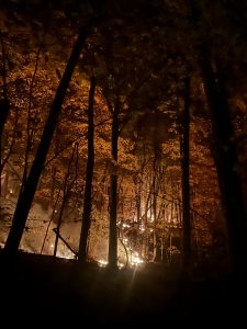
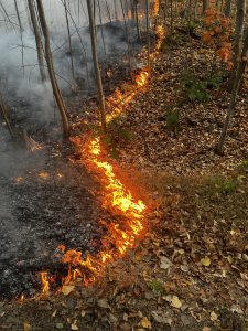
Late in October of 2024, hundreds of fires were scattered across Connecticut, including the Hawthorne Drive Fire, which engulfed about 130 acres of land in Berlin and Meriden. As a result, the governor declared a state of emergency.
The conditions were ideal after a dry summer that transitioned into a warm, dry autumn. Unfortunately, this is an increasingly common situation that is leading to more Connecticut wildfires, or “brush fires” as they are called locally.
To help raise awareness, UConn Fire Department (UCFD) Fire Chief Christopher Renshaw ’01 (CAHNR), ’07 MS, and UConn Extension and Center for Land Use Education and Research (CLEAR) Extension Educator Emily Wilson collaborated to create a tool, the CT Wildland-Urban Interface/Intermix Viewer, to visualize and educate planners, firefighters, and residents in Connecticut to aid in preparing for future wildfires.
The CT Wildland-Urban Interface/Intermix Viewer project began to crystallize as Renshaw pursued his Executive Fire Officer certification through the National Fire Academy. As a structural firefighter with UCFD, 26 seasons of wildland firefighter experience with the U.S. Forest Service, and a master’s degree focusing on wildlife ecology and fire ecology, Renshaw says he wanted to go beyond writing a paper for his capstone project; he wanted to create something relevant and useful.
“I felt like my education and career pointed me in this direction, naturally,” says Renshaw. “All of those experiences came together to allow me to see patterns and what I was observing in Connecticut for risk and frequency of brushfires.”
Renshaw saw patterns throughout North America that create ideal wildfire conditions, including common management practices that result in an ever-growing stockpile of flammable fuel. Coupled with forest health, climatic changes, and human development, all it takes is a single spark to unleash havoc.
In Connecticut specifically, circumstances like drought and massive tree mortality driven by invasive and exotic species like the emerald ash borer, spongy moth, and other tree diseases and pests have increased fuel availability, density, and distribution, Renshaw explains. Another layer of complexity is what’s known as “the wildland-urban interface,” where the human population meets forests and other areas of non-agricultural vegetation.
“That term alone has never really been applied to Connecticut, because it was always thought to be a western United States issue, when, in fact, the research shows we have 72 to 73 percent wildland-urban interface in our own state,” says Renshaw. “This is a greater percentage by volume than most western states combined.”
With the increasing frequency and occurrences of wildfires locally, Renshaw wanted to explore how prepared we are, so he conducted a survey study of fire departments to capture their perceptions of the factors driving wildfires in Connecticut and to see where we are in terms of preparedness.
“The outcome of the research showed that we are not recognizing some major changes in the health of our forests and that the natural fire regime that Connecticut has evolved within is changing in real time, right in front of us,” says Renshaw.
These results were demonstrated in real life just six months after this research was published, when Connecticut and New England experienced over 200 wildfires, says Renshaw. The response to the fall 2024 wildfires in Connecticut required the help from incident management teams from the National Guard, the Fire Department of New York City, teams from Canada, Idaho, Montana, and Northern California.
“We are living in this changed time, and the strategies and tactics that we’ve used historically are not necessarily appropriate for moving forward. The reality is, it is predictable and through our social contract with the people we are sworn to serve and protect, we have to be prepared to respond to this changing wildfire landscape in Connecticut,” says Renshaw.
That’s where Emily Wilson and the talents of UConn CLEAR step in. Wilson has been with CLEAR for 25 years and recognizes where geographic information systems (GIS) can provide the platform for viewing land use information in ways that aren’t normally accessible. The layers compiled within the CT Wildland-Urban Interface/Intermix Viewer that Wilson built can help answer questions about the response capacities of different towns and fire departments. Wilson says that understanding the context and putting the different layers of information together, like the causes of tree damage and mortality rates, the footprints of previous fires, the locations of fire departments around the states, and of course, the interface between human developments and wildlands, resulted in an eye-opening and revealing tool.
“We can see these changes with our own eyes,” says Wilson. “That’s really the power of the mapping, to show them together, and then things really start to pop. As I explain this issue to people, it’s not a one or two-sentence description. It requires seeing and understanding the overlapping problems and contributing factors that inform the issue.”
Wilson and Renshaw also created a story map that introduces and explains the contributing factors and how to explore and understand the maps layers. Story maps are increasingly helpful resources for planners and residents, says Wilson.
“When we add the damage areas and the fire risk together, relating it to the local experience is powerful,” she says. “Combining maps with local issues is a combination that CLEAR and its educational programs use as a foundation for impactful outreach and education.”
Wilson and Renshaw put the CT Wildland-Urban Interface/Intermix Viewer to the test by looking at the footprint of the Hawthorne Drive fire in Berlin last fall.
“Wilson is amazing, and the work CLEAR does is so important. Using the map, we saw that all the layers of damage were exactly the footprint of the fire. It was proven that all this stuff is real; the threat and the risk came together with an actual fire. It was a demonstration of this powerful tool,” says Renshaw. “When you zoom out on that map, you recognize all the other places across our state that have that same overlap and realize that we’re standing in it. We’re in hoarding conditions in our state as far as fuel and the potential for wildland fire, seeing that on that day was interesting and eye-opening.”
Wilson points out that this project aligns well with Extension’s new focus on disaster prevention.
“It is perfect timing for this initiative. No wildland fire in Connecticut should be a surprise at this point, given what we know,” says Wilson.
Renshaw says the next step is continued outreach and educational initiatives, including classes he began teaching earlier this year to fire departments in the state on strategies and tactics for responding to brush fires in the wildland-urban interface.
“We have to evolve as an eastern fire service to learn these strategies and techniques to be successful, not only in our mission, but also to protect the firefighters themselves,” says Renshaw. “We should also be looking at our residential areas and where those layers overlap. That’s where your risk is the greatest for loss of life and structures, so if you have money to put toward fuel mitigation, now we know where to look to make sure we get the best bang for your buck.”
Renshaw points out another important implication is that insurance companies have already begun to look at property values in terms of wildfire risk, and that it is just a matter of time before the state starts to see increasing homeowners’ insurance rates.
With this mapping tool, it is possible to start employing prevention practices, and the networks for relaying the messaging have already been established by the fire services, says Renshaw, through similar safety campaigns like changing smoke alarm batteries when the clocks change in the spring and fall.
“We could add to that list that it is time to clean out your gutters and make sure the area around your house is free of vegetative fuel because it’s brush fire season,” says Renshaw.
Though the project is one that both Renshaw and Wilson work on in addition to their normal duties, it is a meaningful endeavor.
“I think we’re both compelled by how important this is, because at the end of the day, it demonstrates risk to human lives,” says Renshaw. “Getting this data out there in ways that can be consumable by people with the ability to respond to these risks may have a direct relationship with saving lives.”