UConn Department of Marine Sciences Professor Heidi Dierssen and an international team of researchers are eagerly awaiting the launch of a satellite that will help them see the world’s oceans and atmosphere in entirely new ways.
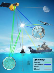
Light reflecting from the ocean, called ocean color, or off aerosol particles suspended in the atmosphere yields information about various conditions and dynamic processes. This spectral data changes depending on concentrations of things like plankton, dissolved organic matter, or even microplastics in the water, or air pollution, pollen, or sea spray in the air, yet collecting this data can be tricky unless you have instruments specifically calibrated for this purpose.
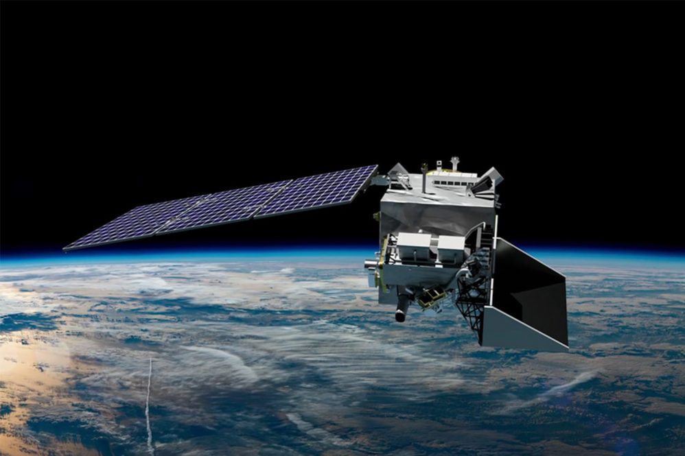
Dierssen has researched ocean color satellite imagery throughout her career and now she is playing a key role in strategic planning with NASA and various parts of the PACE (Plankton, Aerosol, Cloud, ocean Ecosystem) ocean color mission. PACE is NASA’s most advanced ocean-observing satellite and will continue important work to monitor ocean health and air quality, as well as fill blind spots from previous sensors by measuring in a broader range from the UV to infrared ends of the spectrum. Dierssen explains that the NASA PACE satellite is especially exciting because the new sensors allow researchers to conduct novel research. The satellite is scheduled to launch on February 6th, 2024, on a SpaceX Falcon 9 rocket at Cape Canaveral Space Force Station in Florida.
“This is our first NASA launch of a much-advanced satellite that’s going to look at the oceans in a completely new way,” Dierssen says.
Much of Dierssen’s work currently relies on groundwork and aircraft sensors, so having the PACE satellite scanning Earth’s seas around once per day will deliver more data than previously available, including information crucial to tracking ocean health, air quality, and climate.
PACE is designed explicitly for global oceanic research, says Dierssen. The sensitivity of the PACE Ocean Color Instrument (OCI) is specifically designed to capture very subtle changes in ocean color that are challenging to detect with sensors designed for terrestrial applications. Furthermore, the OCI tilt will help avoid sun glint, and the single detector design will inhibit image striping, which is a common problem with existing ocean color satellites like MODIS and VIIRS.
“We were very clear when we came up with the concept to have PACE be ocean-optimized, which is exciting because it’s designed to maximize our ability to see ocean life and biology, phytoplankton, communities, community composition, and biodiversity, globally. It has taken a long time to sort out the hardware and data processing now that every pixel will have so much more data globally. It has taken some maturation of the technological end of things to be able to conceptualize collecting that much data from space,” says Dierssen.
The mission is an enormous team effort, Dierssen explains, with an international team of researchers applying their expertise.
PACE’s hyperspectral Ocean Color Instrument (OCI) was built at the NASA Goddard Space Flight Center and Dierssen says the instrument is a monumental addition to the satellite because researchers have not had access to routinely collected hyperspectral data until PACE and this kind of data will pave the way for exciting new research.
“We have been experimenting with data from all over the world looking at coral reefs and seagrasses,” Dierssen says. “There’s been a couple of test cases and I have some papers from a sensor on the international space station. Now, with our Italian colleagues, I’m working with some imagery, but we must do test runs to see what we can do with the imagery.”

Dierssen was on the first PACE science team that pitched the concept and for the last three and a half years, Dierssen has been serving as the science and applications team leader. With around 100 people on the team from across the globe, Dierssen has focused on synergizing the expertise everyone brings to the project.
“We often need products that are produced by other teams in the pipeline or ways to model things better,” she says. “We have an atmospheric team and an ocean team, but our teams are very combined because we must know how to deal with the atmosphere and how to deal with the ocean and vice versa. I wanted to understand the dynamics between a coupled ocean-atmosphere and bringing both sides together has been successful.”
Now, Dierssen says they are tackling uncertainties and gaps and how to move measurements into the ultraviolet, which has presented atmospheric and ocean challenges.
“This will be the first sensor to measure ocean color into the ultraviolet,” Dierssen says. “Then we have two polarimeters, the SPEXone Polarimeter and HARP2 Polarimeter, which are looking at the ocean through a polarized lens. I don’t think we know, exploratorily, what we’re going to see, but it’s going to help us a lot with clouds, aerosols, and all the atmospheric work. We don’t know how it’s going to revolutionize how we model ocean biology and life and what we will be able to see well with those polarimeters combined with hyperspectral imagery.”
Dierssen says there is always a degree of excitement when new sensors are deployed, because there are always new and unanticipated findings. With the polarimeters, researchers will likely get a more powerful look at things like oil spills and surfactants used in cleanups, for instance, but also new insights into how ocean surface conditions are altered by climate change. PACE will also measure chlorophyll fluorescence in the red part of the spectrum with higher precision than previous sensors.
Dierssen explains that an important part of measuring ocean color is to avoid sun glint as much as possible:
“The way PACE is going to image ocean color is it has a tail 20 degrees away from the sun, and then as it crosses the equator, it does an engineering feat where it flips so that it looks the other 20 degrees away so it’s constantly maintaining an angle away from the sun to avoid glint. It will provide a lot more data for us along the equatorial regions and across various seasons. It’s also a different design, what we call a whisk broom, which means it’s sensing as the satellite is moving by quickly rotating and picking up an image as it goes. This will reduce artifacts like striping common to many ocean color images.”
With the highly calibrated sensors aboard PACE, Dierssen says they will be able to collect precise climate-quality data to track how the oceans are changing. PACE will also provide imagery over snow and ice and land surfaces.
“We should get data from most of the Earth every day, so we will get subtle spectral details that are completely different than what we’ve seen before,” she says. “The oceans are so vast that even with boats we cannot get this kind of data throughout much of the world and now to have these space assets looking down at the ocean is critical. Once PACE launches and is commissioned, we will be seeing the global ocean in a novel way to explore and make new discoveries.”


